© Oliver Keppelmüller 2017-2018


Developer’s blog


A Battlefield is Born
27th January 2018 by Ilja Varha
ROAD TO A BATTLEFIELD
With the game’s battlefield features finalized, and editor tools ready, work on the battlefield
maps has begun. While Oliver is busy finalizing the battle UI and coding core battle
elements like morale-system, and Peter giving the final touches to unit sprites, I am
producing the battlefields. The work begins with research. Sounds easy enough, but can be
challenging.
First of all, there are the historical maps used by the commanding generals or drawn right
after the battle. These usually highlight the important features of the battlefield, but are not
very accurate. The scale varies, and there is no measured topography to speak of. And
sometimes they are missing features the drawers did not know about at the time.
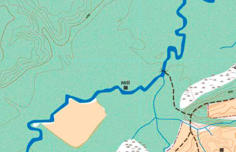
Maps portray important information for the commander. While the left map could be
sufficient for ordering large bodies of troops (or not), its topography and scale are rarely
even satisfactory. The right map could be more accurate, but spans less than 50% of the
battlefield in question.
Modern day maps are openly available online, but most of the historical battle locations
have changed dramatically over time: forests have been cut, cities expand, rivers are
diverted, terraforming in general. And many old roads, used by the troops in the battle, have
ceased to exist long ago. So the battlefields have changed. Some battlefields have been
thoroughly researched, some not so. Though there are some gold mines like maps from
early 20th century, where topographic measurement was already quite accurate, and
countryside had not yet changed dramatically.
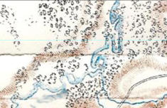
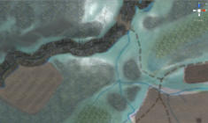
From all these sources I create a reference map, draw a height map, and then so called
alpha map, that I use for drawing the terrain itself on the 3D terrain.
Drawing the contours to produce a heightmap, from which the battlefield’s 3D terrain is
created from. After importing, it will be further refined by hand where needed.
When the detailed alpha map is laid on the 3D terrain, the terrain types can be painted over
it. Terrain types contain values like slowing down troop movement or cover provided. The
terrain is then populated with trees, brush, bushes… These will change appearance
according to season. Water is added, and by default cannot be crossed. For this purpose
bridges and fords are added, and in-game also pontoon bridges can be built on suitable
locations.
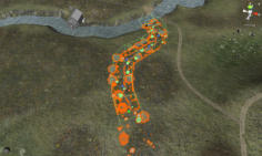
After the terrain is painted, roads, smaller streams, fences, are added. These elements
contain information like cover values, and navigation costs for pathfinding, and most of
them can be used for automatic placement of troops during game. Troops will follow roads
in march columns for best speed and for example stone walls provide obstacle for artillery.
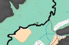
Painting the terrain types in 3D editor, using an alpha map (left), and then drawing the
active battlefield elements, like the small stream here. The stream will slow troops down,
but will also provide some natural cover if defensive line is placed there.
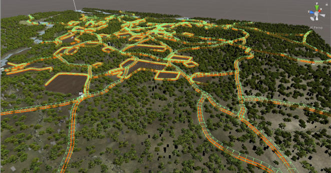
When the elements are placed, the map will start to look like a web - or a maze which will
provide realistic challenges and opportunities for the opposing armies. Taking advantage of
the terrain can provide crucial, as for example sunken roads are like natural trenches for a
defender to anchor his line in, and narrow terrain will channel movement of even a
numerically superior force.
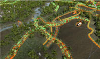
Last thing is to add entry points and objectives on the map. Entry points allow
reinforcements joining the battlefield according to maneuvres on campaign layer of the
game, but can also be blocked by opposing troops. Objectives are placed on commanding
features of the map, and these will be fought over by the opposing armies in order to control
the field. In historical battles, the maps will also feature fixed entrenchments. But in
campaign game these need to be planned and built by the armies.
And after that, the map is ready to be added in the game! Some balancing needs to be made
later on, especially in the amount of trees and undergrowth, so the battlefield will not be a
memory hoarder.
…but now back to drawing, as there’s a bunch of maps that need to be done!
Ilja


In Grand Tactician, you will be fighting your enemy in large, historical battlefields, up to
some 13 x 13 kilometers in size. The battles can rage for multiple days, with fortunes
changing as objectives are taken or lost and reinforcements rushed in. Same historical
battle maps will also be used in the campaign game. Here’s a quick story of how the
battlefields are created, and what features they will have.